FAQ
To navigate, click topic in index to the right or search (Ctrl+f).
1 Setup project
1.1 Set up the overall project world
1.1.1 The scale of my map is wrong
- The
cellsizein the header of the imported .csv file is wrong. In dBSea you can use theSet world scalefunction to rescale your project. If the problem persists, open.csvin GIS editor or in another suitable software and set correct cellsize (maybe your cells are not square – see point 2). - Cells are not square, i.e. each cell is rectangular, extending further north-south than east-west (or the reverse). dBSea assumes square cells i.e. it expects that a map of dimensions X by Y data points is also X * cellsize by Y * cellsize in size. Use GIS software to re-sample map.
2 Sound Sources
2.1 Spectrum
2.1.1 What is Crest Factor?
The crest factor takes into account that spectrum levels are RMS levels and some peaks may have been “smoothed out” by this form of averaging. E.g. if crest factor is set 12 dB, SPLpeak will be calculated as 12 dB higher than the RMS value. Note that when using the NOAA weightings crest factor is not used directly as a measure of impulsivity.[1]
2.1.2 NOAA Classification of Impulsive and Non-Impulsive sounds
NOAA defines impulsive sounds as: [Sources that] produce sounds that are typically transient, brief (less than 1 second), broadband, and consist of high peak sound pressure with rapid rise time and rapid decay (ANSI 1986; NIOSH 1998; ANSI 2005).
And non-impulsive as: [Sources that] produce sounds that can be broadband, narrowband or tonal, brief or prolonged, continuous or intermittent and typically do not have a high peak sound pressure with rapid rise/decay time that impulsive sounds do (ANSI 1995; NIOSH 1998).
For sound classified as impulsive under this definition NOAA advises that 15 dB should be added to SELcum received levels, and 6 dB to SPLpeak received levels to account for impulsive sounds being likely to have a higher risk of causing injury.[1]
2.2 Multiple Sources
2.2.1 How do I add background noise levels?
As per dBSea 1.3.10 background levels cannot simply be added to dBSea scenarios. We have not prioritised this as noise levels only a little above background levels will be unaffected anyhow.
For example: If noise from a ship is measured at 123 dB (with background noise) and background noise is 120 dB (when the ship is absent), the ship was responsible for 97.54% of the sound pressure. At higher noise levels and higher differences this effect increases (Image 1).
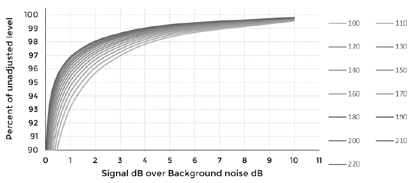
Image 1. If background levels are just 3 dB under signal levels they contribute less than 3% to the total sound pressure level (less at higher levels). The different lines correspond to different sound pressure levels, the louder the noise, the smaller the contribution from less loud background noise.
2.3 Moving sources
2.3.1 How does the program interpret a moving source?
A moving source is modelled by making a series of discrete calculations along the moving path. The path waypoints and the number of intermediate calculation points are set by the user. More points give a better approximation, but increase computation time. No true line source calculation is possible, due to the varying bathymetry.
2.3.2 How does source speed influence my results?
The speed affects the source level by compensating for the amount of time spent at any given point. Notice that if two moving sources are present in the same scenario, the one of longer duration sets the time duration of the scenario. Hence a moving source of shorter duration will appear as having lower noise levels as it will be inactive for part of the scenario.
2.4 Time Series
2.4.1 How does dBSea handle surface ghosts?
The ray solver assumes a perfect reflection from the water surface. If the imported time series has no surface ghost (reflection), the Initial angles range Preferences → Advanced, Initial angles range should be set wide enough, so that some rays travel upward. The solver will create that ghost from the surface reflection. If the imported time series includes a surface ghost, angles should be set to exclude paths towards the surface.
2.4.2 Can I use dBSea Ray for low frequencies – no other solver is available for time series?
The model assumptions are not met for the ray tracer at low frequencies; however, outputs have been found to agree well with low-frequency solvers (Comparison of Modelling Approaches to Low-Frequency Noise Propagation in the Ocean, conference paper, Oceans Korakas & Hovem, 2013, along with in-house testing). Caution should be exercised in shallow water at low frequencies, as this is where the greatest deviations are expected to occur. An initial comparison between solvers in the frequency domain may show whether dBSeaRay is giving incorrect outputs.
3 Solver and Frequencies
3.1.1 Are Nx2D solvers sufficient for my scenario?
For most scenarios, Nx2D (2D radially symmetric) solvers are suitable. As levels are calculated in straight lines out from the source, areas without direct line of sight to the source will typically show no levels, or levels that are too low, depending on the local bathymetry. If you have many small islands in your scenario, untick Stop marching solution upon reaching land in Preferences → Advanced.
For scenarios where the 2D radial symmetry assumption is not valid, dBSea v3 includes full 3D solvers (dBSeaPE 3D and dBSeaRay 3D) that model propagation in all directions.
3.1.2 I have a Solver found no modes at location error, what does this mean?
For low frequencies mode 'shapes' are very large and in shallow water that can lead to a situation where the root finder finds no solution. In recent releases the program will extent the sediment depth to try and find at least one mode. This means that low frequency energy will not propagate well in this situation.
3.2 Frequency Selection
3.2.1 What should my crossover frequency be?
No simple answer exists for this problem. Generally 125-1000 Hz is a good place to start, but other (often lower) crossover frequencies can work. Some experimentation is advised. See blog post: Divide and Conquer
3.3 Solvers
3.3.1 Which solvers support directivity?
As of v3.0.11, directivity is supported by dBSeaRay (3D and 2D) and dBSeaPE (3D and 2D). The simple geometric spreading solvers (10 log, 20 log) do not support directivity.
3.3.2 How accurate are the solvers?
There’s no simple answer to this, but all solvers are tested and validated against benchmark solvers from Computational Ocean Acoustics (Jensen 2011). The dBSea solvers will give slightly higher levels when the Levels must decrease with distance is ticked and the Radial smoothing factor is different from zero. We continuously validate and update the solvers as we obtain more real world data.
3.3.3 I get no values close to the source when using the ray tracer?
This is most likely caused by having the angle of the ray tracer set too narrow. Open Preferences → Advanced and adjust Initial angles range and Initial step size.
4 Overall Sound Levels
4.1 Change Limits
4.1.1 Exclusion zone and sound level contours are not equal
The exclusion zone is calculated radially around the source and is made to give a contiguous area. The user also has the option of choosing a different radial smoothing factor for the exclusion zone.
4.1.2 I’ve ticked the Show exclusion zone box, but no exclusion zone appears/exclusion zone looks very irregular.
- Check the you have selected a criterion in either the
Exclusion zone level (dB)box or theChoose thresholddropdown menu. - The exclusion zone is partly based on the amount of radial slices used Setup project → Radial slices. If the number of slices is set lower than 3, no exclusion zone will be visible. Also keep in mind that using very few radial slices in a complex scenario, will severely impact accuracy.
5 Water properties and Sound speed profile
5.1 Sound speed profile
5.1.1 I get a very irregular sound field.
Depending on the scenario, very sudden changes in sound speed can cause the model to output unexpected results. Try to make the sound speed profile more smooth by adding more points in the Sound speed profile window.
5.2 Attenuation Profile
5.2.1 Why does results remain the same after I change the temperature of the water?
Frequency specific attenuation is only relevant at high frequencies (>10 kHz), so often the soundscape (and the results) will be dominated by lower frequencies, whose propagation is not/barely affected by temperature. The absorption graph (accessed via the tab buttons next to the temperature and salinity input) shows the current absorption curve.
5.2.2 How does temperature and salinity affect propagation?
Under 10 kHz frequency specific attenuation is <1dB/km and salinity and temperature only accounts for a very little part of this.
Try National Physics Laboratory’s calculator.
6 Graphics Window
6.1 Land is not land coloured
In ESRI Ascii grid .asc files, areas may be given as NO_DATA, meaning there is no measured height or depth at that point. dBSea treats this differently than land. You can set the display colour for NO_DATA areas on the preferences form.
6.2 The Bathymetry is inverted/upside down
dSBea interprets positive values as depths and negative values as heights. Two ways to fix this in dBsea:
- Tools → Swap heights and depths (this does not change the bathymetry file, but will be stored in the
.UWAfile) - Open CSV-editor. Tools → Launch CSV Editor. Import your bathymetry, press
Translate, chooseReverse heights and depths.Export current selection. (This stores a new bathymetry file with swapped heights and depths).
7 Exporting
7.1 The Export to GIF returns an error
When using the gif-tool, dBSea has to save and access values at all positions along any given track. On some computers this intense use of memory can lead to an error. To resolve this, try to either free up some RAM-space (by closing other applications) or reduce some parameter of you model (size of calculation grid, number of frequencies solved for, dB-resolution or showing fewer depth slices)
8 CSV Editor
8.1 Bathymetry import
8.1.1 What coordinate system does the CVS Editor use?
CSV Editor and dBSea both use meters Easting/Northing internally.
ESRI Ascii Grid files have a header that specifies the location and size of the data. This can be given in meters, or in degrees latitude/longitude. dBSea will guess that degrees are used if the values are all less than ±360°. If you confirm that the coordinates are in degrees, dBSea will attempt to convert to meters using an UTM zone, with the zone chosen based on the middle of the import area.
Files where the locations are given in degrees are necessarily skewed due the curvature of the Earth. These effects are greater closer to the poles, and for large areas. If the skewing is too great, conversion in a GIS package to easting/northing in meters is recommended.
Note that UTM-zones around Skagerak (Denmark/Norway) and Svalbard (Norway) are skewed (UTM Zones Map).
The CSV Editor/dBSea currently does not take these irregularities into account, so if you do work in any of these six zones, check and manually correct the northing/easting. From dBSea v1.3.8 there is a latitude/longitude to easting/northing calculator available to aid with coordinate conversion.
9 Results
9.1 Results are wrong
9.1.1 Sources don't contribute correctly to scenario sound levels.
In early versions of dBSea (1.2.0-1.3.10), there were issues with multi-threading in complex scenarios. This was resolved in version 1.3.11 and later. If using an older version, disable multicore solves in Preferences → Multicore.
10 Memory
10.1.1 I’m running out of memory
Storing all the calculated sound levels takes a large amount of memory. This can be reduced by lowering the number of source slices, range points, depth points, frequencies, and x and y output grid points.
You can also use our model size calculator. Simply, update the numbers in the input section.
11 Miscellaneous
11.1 Does DBSea work in fresh water?
Yes, simply set the salinity to 0.
11.2 Can I run DBSea in bath mode?
At present this is not an option. You can use the Scenarios tab to test the effects of different parameters on your solution.
11.3 dBSea on Linux and macOS
dBSea v3 is available for Linux (Debian/Ubuntu) and macOS. Contact the dBSea team for details. Wine is no longer required.
12 Terms and abbreviations
- Batch mode: Terminology describing the process of applying the same algorithm to multiple files.
- ESRI Ascii grid: Simple Unicode character exchange format. Data is gridded and encoded as text.
- Multi-Threading: Running several processes in parallel.
- RMS: Root Mean Square, a common way to assess energy content of sound.
13 References
- NOAA. Guidance for Assessing the Effects of Anthropogenic Sound on Marine Mammal Hearing. National Oceanic and Atmospheric Administration, 2015.